
Hurricane Jose Coordination Message #2 – Tuesday 9/19/17-Wednesday 9/20/17 Possible Jose Impacts
Hello to all..
..Jose Regains Hurricane Status as of 500 PM EDT – Friday September 15th, 2017..
..Hurricane Jose is expected to continue to at least gradually intensify and he is now on the move to the Northwest at 10 MPH. It is expected to gradually turn North-Northwestward and Northward over the next few days and continue to move parallel to the US East Coast with the possibility of direct impacts in Southern New England in the Tuesday to Wednesday timeframe. Latest National Hurricane Center (NHC) advisory mentions interests from North Carolina northward to New England should monitor the progress of Jose..
..The extent on specifics of impact are too early to state at this time but swells and rip currents along the New England Coast are likely. Heavy Rain, Gusty Winds, and Coastal Flooding and Beach Erosion along the South Coast of New England are potential threats..
..VoIP Hurricane Net and Hurricane Watch Net management are monitoring the progress of Jose. Since it is not near land, they are not active at this time..
..Interests in Southern New England should begin monitoring the progress of Hurricane Jose. This message’s intent, at this very early stage, is to have folks begin the monitoring process. SKYWARN Activation with Ops at NWS Taunton are possible some time Tuesday into Wednesday presuming direct impacts of some kind into Southern New England occur..
Hurricane Jose is currently a 75 MPH category-1 hurricane and is now on the move to the Northwest at 10 MPH. Over the next few days, Jose is expected to track more towards the northwest and northward with some increase in forward speed and should at least gradually intensify. Model guidance has shifted a bit closer to the coast with some reliable guidance bringing Jose to near the 40 North/70 west benchmark just south of Nantucket or perhaps within 10-20 miles of Nantucket Island. Other models are further west while others are still further east and there remains considerable spread in the guidance. The NHC advisory mentions interests from North Carolina to New England should monitor the progress of Jose so that necessitates continuing coordination messages. Given the spread in the model guidance, it is too early to state any direct impacts with the exception of swells and rip currents along the New England coast which are likely as we get into the weekend and early next week. Heavy Rains, Gusty Winds, and Coastal Flooding to South Coastal New England are all potential threats pending the track of Jose if a closer to the coast impact verifies Tuesday into Wednesday. The track error ‘cone of uncertainty’ now covers much Southern New England with the latest forecast package with Cape Cod and the Islands and Southeast Coastal Massachusetts at most risk for direct impacts currently. A few key items for consideration as we continue to monitor Jose’s progress:
1.) Jose will strengthen a bit over the weekend and then gradually weaken as it moves up to New England. Models are varying the speed of Jose on his closest approach to the region. This will effect ultimate direct impacts on weather in Southern New England in the Tuesday to Wednesday timeframe presuming a close enough track to affect portions of Southern New England.
2.) The size of Jose will expand as he moves up the coast and he may start a transition into a post-tropical system which may allow wind fields to expand further including on the west side of the system.
Amateur Radio and Non-Amateur Radio SKYWARN Spotters should continue to keep high situational awareness regarding the track and intensity of Hurricane Jose. People should gradually begin reviewing their preparedness measures for tropical storm/hurricane force conditions as a precaution. This information has been provided via the Hurricane Preparedness Week at a link to that is below:
Hurricane Preparedness Week Public Information Statements of Safety Tips via the link below:
http://beta.wx1box.org/local/hurr_prepare_week_2017.txt
Once again, Hurricane Jose should be monitored closely by people in Southern New England. The latest NWS Taunton Hazardous Weather Outlook and advisory and key messages information on Hurricane Jose are listed below:
NWS Taunton Hazardous Weather Outlook:
http://kamala.cod.edu/ma/latest.flus41.KBOX.html
NWS Taunton Experimental Enhanced Hazardous Weather Outlook:
https://www.weather.gov/box/ehwo
National Hurricane Center – Miami Florida Information:
Hurricane Jose Public Advisory Information:
http://kamala.cod.edu/TPC/latest.wtnt32.KNHC.html
Hurricane Jose Technical Discussion Information:
http://kamala.cod.edu/TPC/latest.wtnt42.KNHC.html
Hurricane Jose Forecast/Advisory Information:
http://kamala.cod.edu/TPC/latest.wtnt22.KNHC.html
Hurricane Jose Wind Speed Probabilities:
http://kamala.cod.edu/TPC/latest.font12.KNHC.html
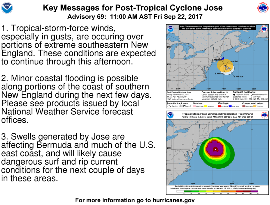
Hurricane Jose Key Messages Slide:
http://www.nhc.noaa.gov/news/AL122017_key_messages.png
The next coordination message will likely be posted some time Saturday pending further computer model data on the track of Jose and significant updates to Jose’s status as a tropical system from an intensity perspective.
Respectfully Submitted,
Robert Macedo (KD1CY)
ARES SKYWARN Coordinator
Eastern Massachusetts ARES Assistant Section Emergency Coordinator
Home Phone #: (508) 994-1875 (After 6 PM)
Home/Data #: (508) 997-4503 (After 6 PM)
Work Phone #: 508-346-2929 (8 AM-5 PM)
Email Address: rmacedo@rcn.com
http://ares.ema.arrl.org
http://beta.wx1box.org
Like us on Facebook – http://www.facebook.com/wx1box
Follow us on Twitter – http://twitter.com/wx1box
Hello to all..
..Jose Regains Hurricane Status as of 500 PM EDT – Friday September 15th, 2017..
..Hurricane Jose is expected to continue to at least gradually intensify and he is now on the move to the Northwest at 10 MPH. It is expected to gradually turn North-Northwestward and Northward over the next few days and continue to move parallel to the US East Coast with the possibility of direct impacts in Southern New England in the Tuesday to Wednesday timeframe. Latest National Hurricane Center (NHC) advisory mentions interests from North Carolina northward to New England should monitor the progress of Jose..
..The extent on specifics of impact are too early to state at this time but swells and rip currents along the New England Coast are likely. Heavy Rain, Gusty Winds, and Coastal Flooding and Beach Erosion along the South Coast of New England are potential threats..
..VoIP Hurricane Net and Hurricane Watch Net management are monitoring the progress of Jose. Since it is not near land, they are not active at this time..
..Interests in Southern New England should begin monitoring the progress of Hurricane Jose. This message’s intent, at this very early stage, is to have folks begin the monitoring process. SKYWARN Activation with Ops at NWS Taunton are possible some time Tuesday into Wednesday presuming direct impacts of some kind into Southern New England occur..
Hurricane Jose is currently a 75 MPH category-1 hurricane and is now on the move to the Northwest at 10 MPH. Over the next few days, Jose is expected to track more towards the northwest and northward with some increase in forward speed and should at least gradually intensify. Model guidance has shifted a bit closer to the coast with some reliable guidance bringing Jose to near the 40 North/70 west benchmark just south of Nantucket or perhaps within 10-20 miles of Nantucket Island. Other models are further west while others are still further east and there remains considerable spread in the guidance. The NHC advisory mentions interests from North Carolina to New England should monitor the progress of Jose so that necessitates continuing coordination messages. Given the spread in the model guidance, it is too early to state any direct impacts with the exception of swells and rip currents along the New England coast which are likely as we get into the weekend and early next week. Heavy Rains, Gusty Winds, and Coastal Flooding to South Coastal New England are all potential threats pending the track of Jose if a closer to the coast impact verifies Tuesday into Wednesday. The track error ‘cone of uncertainty’ now covers much Southern New England with the latest forecast package with Cape Cod and the Islands and Southeast Coastal Massachusetts at most risk for direct impacts currently. A few key items for consideration as we continue to monitor Jose’s progress:
1.) Jose will strengthen a bit over the weekend and then gradually weaken as it moves up to New England. Models are varying the speed of Jose on his closest approach to the region. This will effect ultimate direct impacts on weather in Southern New England in the Tuesday to Wednesday timeframe presuming a close enough track to affect portions of Southern New England.
2.) The size of Jose will expand as he moves up the coast and he may start a transition into a post-tropical system which may allow wind fields to expand further including on the west side of the system.
Amateur Radio and Non-Amateur Radio SKYWARN Spotters should continue to keep high situational awareness regarding the track and intensity of Hurricane Jose. People should gradually begin reviewing their preparedness measures for tropical storm/hurricane force conditions as a precaution. This information has been provided via the Hurricane Preparedness Week at a link to that is below:
Hurricane Preparedness Week Public Information Statements of Safety Tips via the link below:
http://beta.wx1box.org/local/hurr_prepare_week_2017.txt
Once again, Hurricane Jose should be monitored closely by people in Southern New England. The latest NWS Taunton Hazardous Weather Outlook and advisory and key messages information on Hurricane Jose are listed below:
NWS Taunton Hazardous Weather Outlook:
http://kamala.cod.edu/ma/latest.flus41.KBOX.html
NWS Taunton Experimental Enhanced Hazardous Weather Outlook:
https://www.weather.gov/box/ehwo
National Hurricane Center – Miami Florida Information:
Hurricane Jose Public Advisory Information:
http://kamala.cod.edu/TPC/latest.wtnt32.KNHC.html
Hurricane Jose Technical Discussion Information:
http://kamala.cod.edu/TPC/latest.wtnt42.KNHC.html
Hurricane Jose Forecast/Advisory Information:
http://kamala.cod.edu/TPC/latest.wtnt22.KNHC.html
Hurricane Jose Wind Speed Probabilities:
http://kamala.cod.edu/TPC/latest.font12.KNHC.html
Hurricane Jose Key Messages Slide:
http://www.nhc.noaa.gov/news/AL122017_key_messages.png
The next coordination message will likely be posted some time Saturday pending further computer model data on the track of Jose and significant updates to Jose’s status as a tropical system from an intensity perspective.
Respectfully Submitted,
Robert Macedo (KD1CY)
ARES SKYWARN Coordinator
Eastern Massachusetts ARES Assistant Section Emergency Coordinator
Home Phone #: (508) 994-1875 (After 6 PM)
Home/Data #: (508) 997-4503 (After 6 PM)
Work Phone #: 508-346-2929 (8 AM-5 PM)
Email Address: rmacedo@rcn.com
http://ares.ema.arrl.org
http://beta.wx1box.org
Like us on Facebook – http://www.facebook.com/wx1box
Follow us on Twitter – http://twitter.com/wx1box