Severe Weather and Wind Coordination Message #1 – Sunday Afternoon 3/28/21 Through Monday Evening 3/29/21 Severe Weather and Damaging Wind Potential

Hello to all…

..Strong to Damaging Winds expected late Sunday Night into Monday across much of Southern New England as a strong cold front moves thru the region. In addition, the Storm Prediction Center (SPC) has placed Western and Central Connecticut and Southwest Massachusetts in a marginal risk for severe weather for late Sunday Afternoon & Evening with strong to damaging winds, heavy downpours and frequent lightning as the main threats. This will be contingent on instability and ability of thunderstorms to bring strong winds to the surface..
..A Wind Advisory is now in effect for the entire NWS Boston/Norton Coverage Area from 11 PM Sunday Night to 8 PM Monday Evening for sustained winds 20-30 MPH with gusts up to 55 MPH and isolated higher wind gusts to 60 MPH possible. These winds will cause isolated to scattered pockets of tree and wire damage and power outages..
..SKYWARN Self-Activation will monitor the severe thunderstorm potential late Sunday Afternoon and Evening and the strong to damaging wind potential for late Sunday Night into Monday Evening. Another coordination message will be posted by 11 PM Sunday Evening if any significant changes to the situation occurs and time allows for an update. Below are the NWS Boston/Norton Wind Advisory Statement, Area Forecast Discussion, Enhanced Hazardous Weather Outlook and SPC Day-1 Convective Outlook..

NWS Boston/Norton Wind Advisory Statement:
https://kamala.cod.edu/ma/latest.wwus71.KBOX.html

NWS Boston/Norton Area Forecast Discussion:
https://kamala.cod.edu/ma/latest.fxus61.KBOX.html

NWS Boston/Norton Enhanced Hazardous Weather Outlook:
https://www.weather.gov/box/ehwo

SPC Day-1 Convective Outlook:
https://www.spc.noaa.gov/products/outlook/day1otlk.html

Respectfully Submitted,

Robert Macedo (KD1CY)
ARES SKYWARN Coordinator
Eastern Massachusetts ARES Section Emergency Coordinator
Home Phone #: (508) 994-1875 (After 6 PM)
Home/Data #: (508) 997-4503 (After 6 PM)
Work Phone #: 508-346-2929 (8 AM-5 PM)
Email Address: rmacedo@rcn.com
http://ares.ema.arrl.org
http://www.wx1box.org
Like us on Facebook – http://www.facebook.com/wx1box
Follow us on Twitter – http://twitter.com/wx1box

Severe Weather/Storm Coordination Message #2 – Friday 3/26/21-Saturday Morning 3/27/21 Strong Wind & Severe Weather Potential

Hello to all…

..The Storm Prediction Center has continued portions of Western and Northern Massachusetts in a Marginal risk for severe weather for Friday. Strong to damaging winds, hail and frequent lightning are the primary threats. Also, general strong to damaging winds will occur across much of Southern New England Friday Afternoon through Saturday Morning with the strongest winds in Eastern New England after the cold frontal passage..
..A Wind Advisory is now in effect from 12 PM Friday to 5 AM Saturday for Northern Connecticut, Franklin, Hampden, Hampshire and Worcester Counties of Massachusetts for sustained winds of 10-20 MPH with gusts to 45-50 MPH. A Wind Advisory is now in effect for Rhode Island and all of Eastern Massachusetts from 4 PM Friday to 5 AM Saturday for sustained winds of 10-20 MPH with gusts to 45-50 MPH. These winds could potentially cause isolated pockets of tree and wire damage and isolated power outages..
..SKYWARN Self-Activation will monitor severe thunderstorm and strong wind potential for Friday late morning through Saturday Morning. This will be the last coordination message on this event as we shift into operations mode. Below is the NWS Boston/Norton Wind Advisory Statement, Enhanced Hazardous Weather Outlook, and SPC Day-1 Convective Outlook..

NWS Boston/Norton Wind Advisory Statement:
https://kamala.cod.edu/ma/latest.wwus71.KBOX.html

NWS Boston/Norton Area Forecast Discussion:
https://kamala.cod.edu/ma/latest.fxus61.KBOX.html

NWS Boston/Norton Enhanced Hazardous Weather Outlook:
https://www.weather.gov/box/ehwo

SPC Day-1 Convective Outlook:
https://www.spc.noaa.gov/products/outlook/day1otlk.html

Respectfully Submitted,

Robert Macedo (KD1CY)
ARES SKYWARN Coordinator
Eastern Massachusetts ARES Section Emergency Coordinator
Home Phone #: (508) 994-1875 (After 6 PM)
Home/Data #: (508) 997-4503 (After 6 PM)
Work Phone #: 508-346-2929 (8 AM-5 PM)
Email Address: rmacedo@rcn.com
http://ares.ema.arrl.org
http://www.wx1box.org
Like us on Facebook – http://www.facebook.com/wx1box
Follow us on Twitter – http://twitter.com/wx1box

Severe Weather/Storm Coordination Message #1 – Friday 3/26/21 – Strong Wind & Severe Weather Potential

Hello to all…

..The Storm Prediction Center has placed portions of Western and Northern Massachusetts in a Marginal risk for severe weather for Friday. This is the first outlooked area for severe thunderstorm potential in 2021. Strong to damaging winds, hail and frequent lightning are the primary threats. Also, general strong to damaging winds are possible in Western New England and could affect other parts of Southern New England..
..A Wind Advisory is now in effect from 12 PM Friday to 12 AM Saturday for Northern Connecticut, Franklin, Hampden, Hampshire and Worcester Counties of Massachusetts for sustained winds of 10-20 MPH with gusts to 45-50 MPH. These winds could potentially cause isolated pockets of tree and wire damage and isolated power outages..
..SKYWARN Self-Activation will monitor severe thunderstorm and strong wind potential for Friday late morning through Friday Evening. Another coordination message will be posted by 9 AM Friday Morning. Below is the NWS Boston/Norton Wind Advisory Statement, Enhanced Hazardous Weather Outlook, and SPC Day-2 Convective Outlook..

NWS Boston/Norton Wind Advisory Statement:
https://kamala.cod.edu/ma/latest.wwus71.KBOX.html

NWS Boston/Norton Area Forecast Discussion:
https://kamala.cod.edu/ma/latest.fxus61.KBOX.html

NWS Boston/Norton Enhanced Hazardous Weather Outlook:
https://www.weather.gov/box/ehwo

SPC Day-2 Convective Outlook:
https://www.spc.noaa.gov/products/outlook/archive/2021/day2otlk_20210325_1730.html

Respectfully Submitted,

Robert Macedo (KD1CY)
ARES SKYWARN Coordinator
Eastern Massachusetts ARES Section Emergency Coordinator
Home Phone #: (508) 994-1875 (After 6 PM)
Home/Data #: (508) 997-4503 (After 6 PM)
Work Phone #: 508-346-2929 (8 AM-5 PM)
Email Address: rmacedo@rcn.com
http://ares.ema.arrl.org
http://www.wx1box.org
Like us on Facebook – http://www.facebook.com/wx1box
Follow us on Twitter – http://twitter.com/wx1box

Special Announcement: Chatham Upper Air Station Closure – Prevailing Winds Newsletter and NWS Boston/Norton Flood Safety Awareness Week Statements – Monday 3/15/21-Friday 3/19/21

Hello to all…

A number of topics of interest from this week that we have consolidated into this one special announcement:

The Chatham Upper Air Station will be closing after 8 AM Wednesday March 31st, 2021. The detailed announcement can be seen at the following links:
https://www.weather.gov/media/box/Chatham_Closure.pdf
https://wx1box.org/wp-content/uploads/2021/03/Chatham_Closure.pdf

The Prevailing Winds Newsletter for Spring 2021 has now been published. This Newsletter can be found at the following links:
https://www.weather.gov/media/box/prevailing_winds/2021_03_prevailing_winds.pdf
https://wx1box.org/wp-content/uploads/2021/03/2021_03_prevailing_winds.pdf

An archive of prior Prevailing Winds newsletters can be seen on the wx1box.org web page at the following link:
https://wx1box.org/prevailing-winds-newsletter-archive/

The week of 3/15/21 was Flood Safety Awareness Week in Southern New England and NWS Boston/Norton posted a series of infographics and statements on flood safety. This information can be found at the following links:

NWS Flood Safety Statements and Infographics:
https://www.weather.gov/box/flood_safety

NWS Flood Safety Awareness Week Public Information Statements:
https://wx1box.org/wp-content/uploads/2021/03/PNS_Flood_safety_Awareness_2021.pdf

We hope this information is useful to you as we keep you informed on various happenings in the weather enterprise. Thanks for your support of the NWS Boston/Norton SKYWARN program!

Respectfully Submitted,

Robert Macedo (KD1CY)
ARES SKYWARN Coordinator
Eastern Massachusetts ARES Section Emergency Coordinator
Home Phone #: (508) 994-1875 (After 6 PM)
Home/Data #: (508) 997-4503 (After 6 PM)
Work Phone #: 508-346-2929 (8 AM-5 PM)
Email Address: rmacedo@rcn.com
http://ares.ema.arrl.org
http://www.wx1box.org
Like us on Facebook – http://www.facebook.com/wx1box
Follow us on Twitter – http://twitter.com/wx1box

Storm Coordination Message #1 – Thursday Night 3/18/21-Friday Morning 3/19/21 Coastal Storm Potential

Hello to all…

..Coastal Storm system responsible for the severe weather in the Gulf Coast and Southeast United States will bring rain changing to snow across much of Southern New England with light snowfall accumulations expected with a low probability of low-end moderate snowfall amounts in portions of interior Southern New England along with strong to damaging winds in Southeast Coastal New England Thursday Night into Friday Morning..
..A High Wind Warning is now in effect for Nantucket from 2 AM-11 AM Friday for sustained winds of 30-40 MPH with wind gusts to 60 MPH expected. A Wind Advisory is in effect for Eastern Plymouth County Massachusetts, Cape Cod, Marthas Vineyard and Block Island RI for sustained winds of 25-35 MPH with gusts to 55 MPH expected and isolated higher wind gusts possible. Other parts of East and South Coastal Massachusetts and RI could see wind gusts around or over 40 MPH. These winds will cause isolated to scattered pockets of tree and wire damage and power outages..
..Snowfall across much of the region will be 1-3″ in the interior mostly on grassy surfaces with isolated higher amounts possible. Roads could become slush covered. If higher amounts occur in a more widespread area occur of greater than 3″, than isolated to scattered pockets of tree and wire damage and power outages would be possible but at this time amounts are expected to be below this range. This will be monitored closely as it will depend on how heavy the precipitation and timing of the changeover from rain to snow..
..SKYWARN Self-Activation will monitor this storm system for late Thursday Night into Friday Morning. Amateur Radio Call-Up Nets could be utilized Friday Morning for snow accumulation information as well as strong wind gust/wind damage information at the coast. Another coordination message will be posted by 10 PM Thursday Evening. Below is the NWS Boston/Norton High Wind Warning/Wind Advisory Statement, Area Forecast Discussion, Hazardous Weather Outlook, Snow and Ice Maps and Wind Gust Map..

NWS Boston/Norton High Wind Warning/Wind Advisory Statement:
https://kamala.cod.edu/ma/latest.wwus71.KBOX.html

NWS Boston/Norton Area Forecast Discussion:
https://kamala.cod.edu/ma/latest.fxus61.KBOX.html

NWS Boston/Norton Enhanced Hazardous Weather Outlook:
https://www.weather.gov/box/ehwo

NWS Boston/Norton Snowfall Map:
https://www.weather.gov/box/winter

NWS Boston/Norton Wind Gust Map:
https://wx1box.org/wp-content/uploads/2021/03/NWS-Wind-Gust-Forecast-3_18-3_19.png

Respectfully Submitted,

Robert Macedo (KD1CY)
ARES SKYWARN Coordinator
Eastern Massachusetts ARES Section Emergency Coordinator
Home Phone #: (508) 994-1875 (After 6 PM)
Home/Data #: (508) 997-4503 (After 6 PM)
Work Phone #: 508-346-2929 (8 AM-5 PM)
Email Address: rmacedo@rcn.com
http://ares.ema.arrl.org
http://www.wx1box.org
Like us on Facebook – http://www.facebook.com/wx1box
Follow us on Twitter – http://twitter.com/wx1box

Wind Coordination Message #1 – Sunday Afternoon 3/14/21-Monday Morning 3/15/21 – Strong to Damaging Wind Potential

Hello to all…

..Strong to Damaging Winds Expected Across Southern New England Sunday Afternoon into Monday Morning across Southern New England. Bitter cold conditions will occur tonight through Monday Night and then temperatures will moderate. If going outdoors, dress for the conditions particularly given the warm weather experienced late last week..
..A Wind Advisory is now in effect for the entire NWS Boston/Norton coverage area starting at 12 PM Sunday through 12 AM Monday except for Cape Cod and the Islands where the advisory is in effect through 11 AM Monday for sustained winds of 20-30 MPH with gusts to 50 MPH likely with isolated higher wind gusts possible. These winds will cause scattered pockets of tree and wire damage and scattered power outages..
..SKYWARN Self-Activation will monitor the strong to damaging winds and reports of wind gusts 40 MPH or greater and any wind damage reports for Sunday Afternoon into Monday Morning. This will be the only coordination message on the strong to damaging winds as we shift into operations mode. Below is the NWS Boston/Norton Wind Advisory Statement, Area Forecast Discussion, Enhanced Hazardous Weather Outlook and Wind Gust Map..

NWS Boston/Norton Wind Advisory Statement:
https://kamala.cod.edu/ma/latest.wwus71.KBOX.html

NWS Boston/Norton Area Forecast Discussion:
https://kamala.cod.edu/ma/latest.fxus61.KBOX.html

NWS Boston/Norton Enhanced Hazardous Weather Outlook:
https://www.weather.gov/box/ehwo

NWS Boston/Norton Wind Gust Map:
https://wx1box.org/wp-content/uploads/2021/03/Max-Wind-Gusts-Sunday.png

Respectfully Submitted,

Robert Macedo (KD1CY)
ARES SKYWARN Coordinator
Eastern Massachusetts ARES Section Emergency Coordinator
Home Phone #: (508) 994-1875 (After 6 PM)
Home/Data #: (508) 997-4503 (After 6 PM)
Work Phone #: 508-346-2929 (8 AM-5 PM)
Email Address: rmacedo@rcn.com
http://ares.ema.arrl.org
http://www.wx1box.org
Like us on Facebook – http://www.facebook.com/wx1box
Follow us on Twitter – http://twitter.com/wx1box

Wind Coordination Message #1 – Friday Night 3/12/21-Saturday Morning 3/13/21 Strong to Damaging Wind Potential

Hello to all…

..Strong to Damaging Winds Expected Across Southern New England Friday Night into Saturday Morning. Winds will be similar to the Monday Evening 3/1-Tuesday 3/2 event but with a bit less duration on the strongest winds..
..A Wind Advisory is now in effect from 8 PM Friday Evening to 9 AM Saturday Morning for the entire NWS Boston/Norton Coverage Area for sustained winds of 20-30 MPH with gusts between 45-55 MPH with isolated higher wind gusts to 60 MPH possible in the Worcester Hills, East Slopes of the Berkshires and areas of East Coastal Massachusetts. These winds will cause scattered pockets of tree and wire damage and scattered power outages..
..SKYWARN Self-Activation will monitor the strong to damaging winds and reports of wind gusts 40 MPH or greater and any wind damage reports for tonight into early Saturday Morning. Another coordination message will be posted by 9 PM this evening. Below is the NWS Boston/Norton Wind Advisory Statement, Area Forecast Discussion, Enhanced Hazardous Weather Outlook and Wind Gust Map..

NWS Boston/Norton Wind Advisory Statement:
https://kamala.cod.edu/ma/latest.wwus71.KBOX.html

NWS Boston/Norton Area Forecast Discussion:
https://kamala.cod.edu/ma/latest.fxus61.KBOX.html

NWS Boston/Norton Enhanced Hazardous Weather Outlook:
https://www.weather.gov/box/ehwo

NWS Boston/Norton Wind Gust Map:
https://wx1box.org/wp-content/uploads/2021/03/Strong_Wind_Gusts_Friday_Night_3_12_Saturday_Morning_3_13.png

Respectfully Submitted,

Robert Macedo (KD1CY)
ARES SKYWARN Coordinator
Eastern Massachusetts ARES Section Emergency Coordinator
Home Phone #: (508) 994-1875 (After 6 PM)
Home/Data #: (508) 997-4503 (After 6 PM)
Work Phone #: 508-346-2929 (8 AM-5 PM)
Email Address: rmacedo@rcn.com
http://ares.ema.arrl.org
http://www.wx1box.org
Like us on Facebook – http://www.facebook.com/wx1box
Follow us on Twitter – http://twitter.com/wx1box

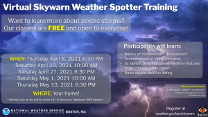
Special Announcement: 2021 Virtual SKYWARN Training Sessions Announced – All 2021 SKYWARN Training Virtual Due to COVID

Hello to all…

Due to COVID-19 concerns, SKYWARN Training classes will again be held virtually. The SKYWARN Training sessions will occur on 3 weeknights and 2 weekends. The weeknight sessions will be taught by NWS forecasters and the weekend sessions taught by Amateur Radio Operators.

Dates and registration information can be seen at the following link:

NWS Boston/Norton Virtual SKYWARN Training dates and registration information link:
https://www.weather.gov/box/skywarn#fragment-2a

All are welcome to attend the training sessions. Those that are interested in becoming a SKYWARN Spotter or existing spotters refreshing their SKYWARN Training can take an optional quiz and that will get a new individual their SKYWARN spotter number and count as refreshing your training for existing spotters.

We hope many can attend these training sessions. Thanks to all for their continued support of the NWS Boston/Norton SKYWARN program!

Respectfully Submitted,

Robert Macedo (KD1CY)
ARES SKYWARN Coordinator
Eastern Massachusetts ARES Section Emergency Coordinator
Home Phone #: (508) 994-1875 (After 6 PM)
Home/Data #: (508) 997-4503 (After 6 PM)
Work Phone #: 508-346-2929 (8 AM-5 PM)
Email Address: rmacedo@rcn.com
http://ares.ema.arrl.org
http://www.wx1box.org
Like us on Facebook – http://www.facebook.com/wx1box
Follow us on Twitter – http://twitter.com/wx1box

Wind Coordination Message #2 – Monday Night 3/1/21-Tuesday PM 3/2/21 – Strong to Damaging Wind and Bitterly Cold Wind Chill Potential

Hello to all…

..A brief Arctic blast will affect the region Monday Night into Tuesday with strong to damaging winds likely Monday Night into Tuesday Morning to early afternoon with bitterly cold wind chills. A few heavier snow showers and snow squalls could affect isolated to scattered parts of the area late Monday Evening..
..A Wind Advisory remains in effect for the entire NWS Boston/Norton Coverage area from 4 PM Monday Evening to Tuesday 10 AM except for Eastern Essex County and the Cape and Islands where the Wind Advisory is in effect through 1 PM Tuesday Afternoon. Sustained winds of 15-35 MPH with gusts to 50-55 MPH with isolated higher wind gusts to 55-60 MPH expected over parts of the Cape and Islands and Eastern Essex County. These winds will cause isolated to scattered pockets of tree and wire damage and isolated power outages..
..A Wind Chill Advisory is now in effect from Midnight to 10 AM Tuesday for Franklin, Western Hampshire, Western Hampden, Northern Worcester and Northern Middlesex Counties of Massachusetts for bitterly cold wind chills of 15 to 20 degrees below zero which can leave frostbite on exposed skin in as little as 30 minutes..
..SKYWARN Self-Activation will monitor the strong to damaging wind potential across Southern New England monitoring for wind gusts 40 MPH or greater and wind damage reports. This will be the last coordination message as we shift into operations mode. Below is the NWS Boston/Norton Wind Advisory Statement, Wind Chill Advisory Statement, Enhanced Hazardous Weather Outlook, Area Forecast Discussion, Wind Gust and Wind Chill Maps..

NWS Boston/Norton Wind Advisory Statement:
https://kamala.cod.edu/ma/latest.wwus71.KBOX.html

NWS Boston/Norton Wind Chill Advisory Statement:
https://kamala.cod.edu/ma/latest.wwus41.KBOX.html

NWS Boston/Norton Area Forecast Discussion:
https://kamala.cod.edu/ma/latest.fxus61.KBOX.html

NWS Boston/Norton Enhanced Hazardous Weather Outlook:
https://www.weather.gov/box/ehwo

NWS Boston/Norton Wind Gust Map:
https://wx1box.org/wp-content/uploads/2021/03/MaxWindGustMphISC_SFC2.png

NWS Boston/Norton Wind Chill Map:
https://wx1box.org/wp-content/uploads/2021/03/MinApparentTISC_SFC1.png

Respectfully Submitted,

Robert Macedo (KD1CY)
ARES SKYWARN Coordinator
Eastern Massachusetts ARES Section Emergency Coordinator
Home Phone #: (508) 994-1875 (After 6 PM)
Home/Data #: (508) 997-4503 (After 6 PM)
Work Phone #: 508-346-2929 (8 AM-5 PM)
Email Address: rmacedo@rcn.com
http://ares.ema.arrl.org
http://www.wx1box.org
Like us on Facebook – http://www.facebook.com/wx1box
Follow us on Twitter – http://twitter.com/wx1box

Wind Coordination Message #1 – Monday Evening 3/1/21-Tuesday Early Afternoon 3/2/21 Strong to Damaging Wind Potential

Hello to all…

..A brief Arctic blast will affect the region Monday Night into Tuesday with strong to damaging winds likely Monday Night into Tuesday Morning to early afternoon with bitterly cold wind chills. A few heavier snow showers and snow squalls could affect isolated to scattered parts of the area Monday Evening around or after the Monday Evening commute..
..A Wind Advisory is in effect for the entire NWS Boston/Norton Coverage area from 4 PM Monday Evening to Tuesday 10 AM except for Eastern Essex County and the Cape and Islands where the Wind Advisory is in effect through 1 PM Tuesday Afternoon. Sustained winds of 15-35 MPH with gusts to 50-55 MPH with isolated higher wind gusts expected. These winds will cause isolated to scattered pockets of tree and wire damage and isolated power outages..
..SKYWARN Self-Activation will monitor the strong to damaging wind potential across Southern New England. Another coordination message will be posted by 1 PM Monday Afternoon. Below is the NWS Boston/Norton Wind Advisory Statement, Enhanced Hazardous Weather Outlook, Area Forecast Discussion, Wind Gust and Wind Chill Maps..

NWS Boston/Norton Wind Advisory Statement:
https://kamala.cod.edu/ma/latest.wwus71.KBOX.html

NWS Boston/Norton Area Forecast Discussion:
https://kamala.cod.edu/ma/latest.fxus61.KBOX.html

NWS Boston/Norton Enhanced Hazardous Weather Outlook:
https://www.weather.gov/box/ehwo

NWS Boston/Norton Wind Gust Map:
https://wx1box.org/wp-content/uploads/2021/03/MaxWindGustMphISC_SFC1.png

NWS Boston/Norton Wind Chill Map:
https://wx1box.org/wp-content/uploads/2021/03/MinApparentTISC_SFC.png

Respectfully Submitted,

Robert Macedo (KD1CY)
ARES SKYWARN Coordinator
Eastern Massachusetts ARES Section Emergency Coordinator
Home Phone #: (508) 994-1875 (After 6 PM)
Home/Data #: (508) 997-4503 (After 6 PM)
Work Phone #: 508-346-2929 (8 AM-5 PM)
Email Address: rmacedo@rcn.com
http://ares.ema.arrl.org
http://www.wx1box.org
Like us on Facebook – http://www.facebook.com/wx1box
Follow us on Twitter – http://twitter.com/wx1box