
Hurricane Jose Coordination Message #5 – Tuesday Evening 9/19/17-Wednesday Night 9/20/17 Likely Jose Impacts
Hello to all..
..Confidence has grown further in tropical storm impacts to portions of Southern New England similar to that of a nor’easter or strong nor’easter type of storm..
..A Tropical Storm Warning is now in effect from Hull Massachusetts to Westerly Rhode Island and includes all of Cape Cod and the Islands including Block Island, Southern Bristol, Southern and Eastern Plymouth Counties of Massachusetts and Newport and Washington Counties of Rhode Island for sustained winds of 20-40 MPH with wind gusts in the 45-60 MPH range with isolated higher wind gusts possible and 2-5″ of rain likely. These winds could cause isolated to scattered pockets of tree and wire damage and isolated power outages as well as urban and poor drainage flooding from heavy rainfall along with minor to moderate coastal flooding and the potential for significant beach erosion.
..Interests elsewhere in Southern New England should closely monitor the progress of Jose as he may bring wind gusts in the 30-40 MPH range and some rainfall which may cause isolated pockets of tree and wire damage across areas north and west of the current Tropical Storm Warning as well as minor coastal flooding issues in coastal areas north of the Tropical Storm Warning..
..A High Surf Advisory remains in effect through 800 PM Monday for Southern Rhode Island including Block Island, Southern Bristol County, Martha’s Vineyard and Nantucket Islands for southerly swell, high surf and rip currents at area beaches from Hurricane Jose. This advisory will likely be extended over the next few days in both time and areal coverage as Jose approaches Southern New England..
..Hurricane Jose is gradually weakening but has a large storm envelope and it will continue to become a larger system with an expanding rain and wind field and will continue to travel northward for the next couple of days and then turn toward the northeast and east around the 40 North/70 West benchmark later Tuesday Night and Wednesday..
..VoIP Hurricane Net and Hurricane Watch Net management are monitoring the progress of both Jose and Maria. These hurricane nets have now activated for Maria and her impact on the Caribbean islands Monday Afternoon through Wednesday and will continue to monitor the progress of Jose. Check out the Hurricane Watch Net web site at http://www.hwn.org and the VoIP Hurricane Net web site at http://www.voipwx.net for more information..
..SKYWARN Activation with Ops at NWS Taunton are likely some time late Tuesday into Wednesday Night with direct impacts in the tropical storm warning area similar to a nor’easter or strong nor’easter type system now likely..
Hurricane Jose is currently a 75 MPH category-1 hurricane and has continues its northward motion. Jose will gradually weaken and go below hurricane strength in the next day or two but Jose’s wind field is expanding and his wind field can continue to expand over the next few days. Jose will continue to track towards the north over the next day or two and then shift to the north-northeast and east and southeast in the 2-5 day period. Model guidance today has continued to hover around the 40 North/70 West benchmark or slightly to the west and north of the benchmark while a few models are little south and east of the benchmark. Tropical Storm Warnings are now in effect for Southeast New England from Hull Massachusetts to Watch Hill Rhode Island along with high surf advisories as indicated in the headlines and the current expected conditions are that of a nor’easter or strong nor’easter as indicated in the headlines of this message. Interests elsewhere in Southern New England should monitor the progress of Jose as areas just to the northwest of the Tropical Storm Warning could see minor coastal flooding at the coast and wind gusts up to 40 MPH with some rain which could cause isolated pockets of tree and wire damage. Factors that are still in play with Jose include the following:
1.) The size of Jose has expanded and will continue to expand as he moves up the coast and he may start a transition into a post-tropical system which may allow wind fields to expand further including on the west side of the system.
2.) The gradient between high pressure in Canada and Hurricane Jose may be a contributing factor to the strong winds over Southeast New England and could allow for some strong winds in other parts of the area north of Eastern New England depending on the track, strength and structure of Jose along with minor coastal flooding along the north shore of Massachusetts.
Amateur Radio and Non-Amateur Radio SKYWARN Spotters should continue to keep high situational awareness regarding the track, intensity and structure of Hurricane Jose. People should be reviewing and implementing their preparedness measures for tropical storm conditions in and near the Tropical Storm Warning area. This information has been provided via the Hurricane Preparedness Week at a link to that is below:
Hurricane Preparedness Week Public Information Statements of Safety Tips and a recently issued Public Information Statement on Tropical Storm preparedness can be seen via the links below:
http://beta.wx1box.org/local/hurr_prepare_week_2017.txt
http://beta.wx1box.org/local/pns_ts_watch_jose_9_17_17.txt
Once again, Hurricane Jose should be monitored closely by people in Southern New England. The latest NWS Taunton Hurricane Jose Local Statement – Tropical Storm Warning Information Statement, High Surf Advisory Statement, Hazardous Weather Outlook and advisory and key messages information on Hurricane Jose are listed below:
NWS Taunton Hurricane Jose Local Statement – Tropical Storm Warning Information Statement:
http://kamala.cod.edu/ma/latest.wtus81.KBOX.html
http://kamala.cod.edu/offs/KBOX/1709181532.wtus81.html
NWS Taunton High Surf Advisory Statement:
http://kamala.cod.edu/ma/latest.whus41.KBOX.html
NWS Taunton Hazardous Weather Outlook:
http://kamala.cod.edu/ma/latest.flus41.KBOX.html
NWS Taunton Experimental Enhanced Hazardous Weather Outlook:
https://www.weather.gov/box/ehwo
National Hurricane Center – Miami Florida Information:
Hurricane Jose Public Advisory Information:
http://kamala.cod.edu/TPC/latest.wtnt32.KNHC.html
Hurricane Jose Technical Discussion Information:
http://kamala.cod.edu/TPC/latest.wtnt42.KNHC.html
Hurricane Jose Forecast/Advisory Information:
http://kamala.cod.edu/TPC/latest.wtnt22.KNHC.html
Hurricane Jose Wind Speed Probabilities:
http://kamala.cod.edu/TPC/latest.font12.KNHC.html
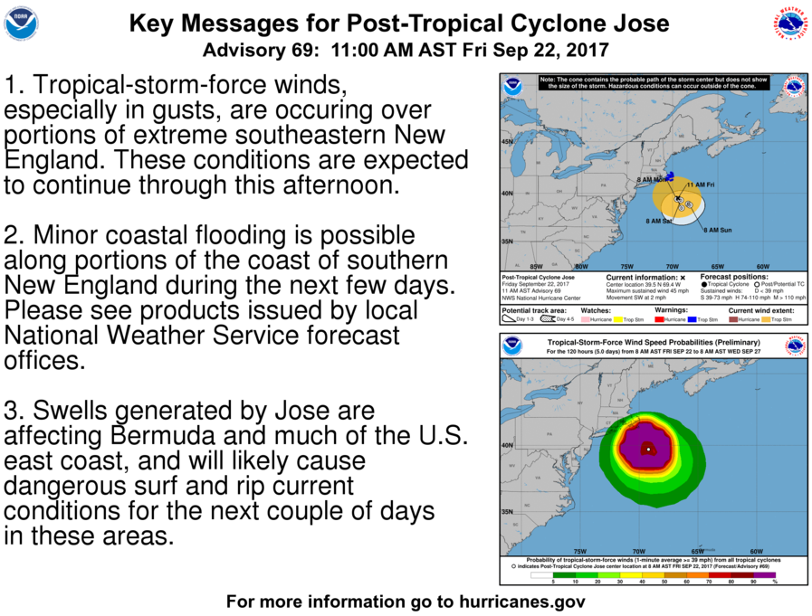
Hurricane Jose Key Messages Slide:
http://www.nhc.noaa.gov/news/AL122017_key_messages.png
The next coordination message will be posted either by 1130 PM Monday Evening or 900 AM Tuesday Morning pending further computer model data on the track of Jose and significant updates to Jose’s status as a tropical system from an intensity perspective and any changes to watches/warnings/advisories for the region.
Respectfully Submitted,
Robert Macedo (KD1CY)
ARES SKYWARN Coordinator
Eastern Massachusetts ARES Assistant Section Emergency Coordinator
Home Phone #: (508) 994-1875 (After 6 PM)
Home/Data #: (508) 997-4503 (After 6 PM)
Work Phone #: 508-346-2929 (8 AM-5 PM)
Email Address: rmacedo@rcn.com
http://ares.ema.arrl.org
http://beta.wx1box.org
Like us on Facebook – http://www.facebook.com/wx1box
Follow us on Twitter – http://twitter.com/wx1box
Hello to all..
..Confidence has grown further in tropical storm impacts to portions of Southern New England similar to that of a nor’easter or strong nor’easter type of storm..
..A Tropical Storm Warning is now in effect from Hull Massachusetts to Westerly Rhode Island and includes all of Cape Cod and the Islands including Block Island, Southern Bristol, Southern and Eastern Plymouth Counties of Massachusetts and Newport and Washington Counties of Rhode Island for sustained winds of 20-40 MPH with wind gusts in the 45-60 MPH range with isolated higher wind gusts possible and 2-5″ of rain likely. These winds could cause isolated to scattered pockets of tree and wire damage and isolated power outages as well as urban and poor drainage flooding from heavy rainfall along with minor to moderate coastal flooding and the potential for significant beach erosion.
..Interests elsewhere in Southern New England should closely monitor the progress of Jose as he may bring wind gusts in the 30-40 MPH range and some rainfall which may cause isolated pockets of tree and wire damage across areas north and west of the current Tropical Storm Warning as well as minor coastal flooding issues in coastal areas north of the Tropical Storm Warning..
..A High Surf Advisory remains in effect through 800 PM Monday for Southern Rhode Island including Block Island, Southern Bristol County, Martha’s Vineyard and Nantucket Islands for southerly swell, high surf and rip currents at area beaches from Hurricane Jose. This advisory will likely be extended over the next few days in both time and areal coverage as Jose approaches Southern New England..
..Hurricane Jose is gradually weakening but has a large storm envelope and it will continue to become a larger system with an expanding rain and wind field and will continue to travel northward for the next couple of days and then turn toward the northeast and east around the 40 North/70 West benchmark later Tuesday Night and Wednesday..
..VoIP Hurricane Net and Hurricane Watch Net management are monitoring the progress of both Jose and Maria. These hurricane nets have now activated for Maria and her impact on the Caribbean islands Monday Afternoon through Wednesday and will continue to monitor the progress of Jose. Check out the Hurricane Watch Net web site at http://www.hwn.org and the VoIP Hurricane Net web site at http://www.voipwx.net for more information..
..SKYWARN Activation with Ops at NWS Taunton are likely some time late Tuesday into Wednesday Night with direct impacts in the tropical storm warning area similar to a nor’easter or strong nor’easter type system now likely..
Hurricane Jose is currently a 75 MPH category-1 hurricane and has continues its northward motion. Jose will gradually weaken and go below hurricane strength in the next day or two but Jose’s wind field is expanding and his wind field can continue to expand over the next few days. Jose will continue to track towards the north over the next day or two and then shift to the north-northeast and east and southeast in the 2-5 day period. Model guidance today has continued to hover around the 40 North/70 West benchmark or slightly to the west and north of the benchmark while a few models are little south and east of the benchmark. Tropical Storm Warnings are now in effect for Southeast New England from Hull Massachusetts to Watch Hill Rhode Island along with high surf advisories as indicated in the headlines and the current expected conditions are that of a nor’easter or strong nor’easter as indicated in the headlines of this message. Interests elsewhere in Southern New England should monitor the progress of Jose as areas just to the northwest of the Tropical Storm Warning could see minor coastal flooding at the coast and wind gusts up to 40 MPH with some rain which could cause isolated pockets of tree and wire damage. Factors that are still in play with Jose include the following:
1.) The size of Jose has expanded and will continue to expand as he moves up the coast and he may start a transition into a post-tropical system which may allow wind fields to expand further including on the west side of the system.
2.) The gradient between high pressure in Canada and Hurricane Jose may be a contributing factor to the strong winds over Southeast New England and could allow for some strong winds in other parts of the area north of Eastern New England depending on the track, strength and structure of Jose along with minor coastal flooding along the north shore of Massachusetts.
Amateur Radio and Non-Amateur Radio SKYWARN Spotters should continue to keep high situational awareness regarding the track, intensity and structure of Hurricane Jose. People should be reviewing and implementing their preparedness measures for tropical storm conditions in and near the Tropical Storm Warning area. This information has been provided via the Hurricane Preparedness Week at a link to that is below:
Hurricane Preparedness Week Public Information Statements of Safety Tips and a recently issued Public Information Statement on Tropical Storm preparedness can be seen via the links below:
http://beta.wx1box.org/local/hurr_prepare_week_2017.txt
http://beta.wx1box.org/local/pns_ts_watch_jose_9_17_17.txt
Once again, Hurricane Jose should be monitored closely by people in Southern New England. The latest NWS Taunton Hurricane Jose Local Statement – Tropical Storm Warning Information Statement, High Surf Advisory Statement, Hazardous Weather Outlook and advisory and key messages information on Hurricane Jose are listed below:
NWS Taunton Hurricane Jose Local Statement – Tropical Storm Warning Information Statement:
http://kamala.cod.edu/ma/latest.wtus81.KBOX.html
http://kamala.cod.edu/offs/KBOX/1709181532.wtus81.html
NWS Taunton High Surf Advisory Statement:
http://kamala.cod.edu/ma/latest.whus41.KBOX.html
NWS Taunton Hazardous Weather Outlook:
http://kamala.cod.edu/ma/latest.flus41.KBOX.html
NWS Taunton Experimental Enhanced Hazardous Weather Outlook:
https://www.weather.gov/box/ehwo
National Hurricane Center – Miami Florida Information:
Hurricane Jose Public Advisory Information:
http://kamala.cod.edu/TPC/latest.wtnt32.KNHC.html
Hurricane Jose Technical Discussion Information:
http://kamala.cod.edu/TPC/latest.wtnt42.KNHC.html
Hurricane Jose Forecast/Advisory Information:
http://kamala.cod.edu/TPC/latest.wtnt22.KNHC.html
Hurricane Jose Wind Speed Probabilities:
http://kamala.cod.edu/TPC/latest.font12.KNHC.html
Hurricane Jose Key Messages Slide:
http://www.nhc.noaa.gov/news/AL122017_key_messages.png
The next coordination message will be posted either by 1130 PM Monday Evening or 900 AM Tuesday Morning pending further computer model data on the track of Jose and significant updates to Jose’s status as a tropical system from an intensity perspective and any changes to watches/warnings/advisories for the region.
Respectfully Submitted,
Robert Macedo (KD1CY)
ARES SKYWARN Coordinator
Eastern Massachusetts ARES Assistant Section Emergency Coordinator
Home Phone #: (508) 994-1875 (After 6 PM)
Home/Data #: (508) 997-4503 (After 6 PM)
Work Phone #: 508-346-2929 (8 AM-5 PM)
Email Address: rmacedo@rcn.com
http://ares.ema.arrl.org
http://beta.wx1box.org
Like us on Facebook – http://www.facebook.com/wx1box
Follow us on Twitter – http://twitter.com/wx1box