
Storm Coordination Message #1 – Late Tuesday Night 9/29/20 Through Midday Wednesday 9/30/20 Strong Wind & Heavy Rainfall Potential
Hello to all…
..Beneficial rainfall expected overnight into late Wednesday Morning but it will also be accompanied by strong to damaging winds over portions of Southern New England..
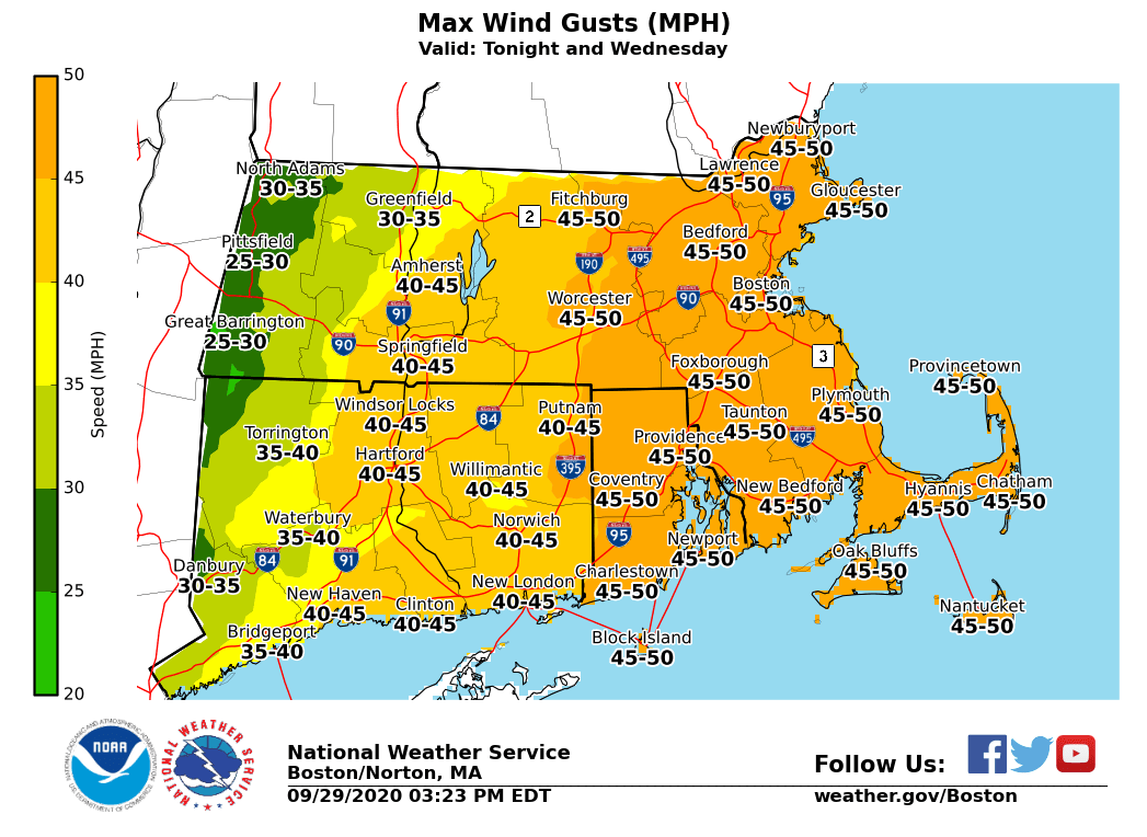
..A Wind Advisory is now in effect from Midnight tonight to 1 PM Wednesday for all of the NWS Boston Norton Coverage area except for Franklin, Hampshire and Western Hampden Counties of Massachusetts for sustained winds of 15-25 MPH and gusts of 40-50 MPH. Isolated to scattered higher wind gusts possible in any fine line of convective showers and thunderstorms bring stronger winds down to the surface. These winds will cause isolated to scattered pockets of tree and wire damage and isolated power outages..
..Rainfall amounts of 1-2″ with isolated higher amounts are likely north and west of Interstate-495 through Northwest Rhode Island and Northern Connecticut. Amounts of 0.25-1.00″ are possible east of I-495..
..SKYWARN Self-Activation will monitor for wind gust measurements, wind damage and rainfall reports of 1″ or more from this storm system..
After an extremely quiet period of weather across Southern New England during the month of September, a strong storm system will bring beneficial rainfall to Southern New England but it will also bring strong to damaging winds to portions of Southern New England. The headlines depict the current thinking. Key factors include:
1.) The fine line of convective showers and possible thunderstorms and their ability to bring the strongest winds down to the surface.
2.) The potential for the intensifying storm system for strong winds to reach the surface. Some models have some stronger winds reaching the surface if enough mixing of the winds can occur. This aspect will be monitored.
SKYWARN Self-Activation will monitor for wind gust measurements, wind damage and rainfall reports of 1″ or more from this storm system. This will be the only coordination message on this storm as we shift into operations mode unless a significant change to the situation occurs and time allows for an update. Below is the NWS Boston/Norton Wind Advisory Statement, Enhanced Hazardous Weather Outlook, Wind Gust Infographic and Rainfall Total Infographic:
NWS Boston/Norton Wind Advisory Statement:
https://kamala.cod.edu/ma/latest.wwus71.KBOX.html
NWS Boston/Norton Enhanced Hazardous Weather Outlook:
https://www.weather.gov/box/ehwo
NWS Boston/Norton Wind Gust Infographic:
https://wx1box.org/wp-content/uploads/2020/09/MaxWindGustMphISC_SFC.png
NWS Boston/Norton Rainfall Infographic:
https://wx1box.org/wp-content/uploads/2020/09/StormTotalQPFISC_SFC.png
Respectfully Submitted,
Robert Macedo (KD1CY)
ARES SKYWARN Coordinator
Eastern Massachusetts ARES Section Emergency Coordinator
Home Phone #: (508) 994-1875 (After 6 PM)
Home/Data #: (508) 997-4503 (After 6 PM)
Work Phone #: 508-346-2929 (8 AM-5 PM)
Email Address: rmacedo@rcn.com
http://ares.ema.arrl.org
http://www.wx1box.org
Like us on Facebook – http://www.facebook.com/wx1box
Follow us on Twitter – http://twitter.com/wx1box