
Large Hail Hits Southern New England in June 5th Severe Weather Event
Hello to all….
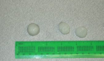
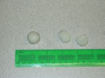
SKYWARN was active with Ops at NWS Taunton as another round of Severe Thunderstorms affected the region on Tuesday June 5th with large hail up to Golf Ball size reported.
 In Hillsborough County, NH, Hillsborough County SKYWARN reported hail pea to quarter sized in several severe thunderstorms that rumbled through Central and Eastern Hillsborough County NH with the first round of storms around 1-2 PM and the second round from 230-315 PM that affected the Nashua and Hudson, NH area as storms moved in from Western and Central Massachusetts. Jim Blaine-WD4JZO and Fletcher Seagroves-N1MEO monitored the situation on the N1IMO linked repeater system.
Across Northern Connecticut, the town of Southington was hit hard with Hartford-Tolland County SKYWARN reporting Penny to Quarter sized hail and a report from NWS Brookhaven, NY of Golf Ball Sized hail damaging cars in Southington as well. SKYWARN was active on the 146.790-Vernon, CT repeater through the efforts of Hartford and Tolland County SKYWARN Coordinator, Roger Jeanfaivre-K1PAI.
Just outside of the NWS Taunton County Warning Area in the city of Naugatuck, CT, hail of up to golf ball size covered the ground to a depth of 5-6″. 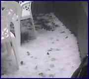
Across Hampden and Worcester Counties, SKYWARN was active on the 146.94-Mount Tom and 146.97-Paxton Repeaters with Ray Weber-KA1JJM, Mark Kimmel-N1ZYG and PJ Howe-N1PJ monitoring for SKYWARN. Penny to Nickel Sized Hail was reported in Chicopee and West Springfield, Massachusetts with Pea to Penny Sized Hail reported in Barre, and Gardner, Massachusetts. In Westminster, Fitchburg, Lunenberg and Townsend, Penny to Half Dollar Sized Hail before those storms moved into Hillsborough County NH.
Special thanks to all those that assisted in this SKYWARN Activation and the past SKYWARN Activations from June 1st and June 2nd. The month of June has been an active month for SKYWARN in the NWS Taunton County Warning Area.
Respectfully Submitted,
Robert Macedo (KD1CY)
ARES SKYWARN Coordinator
Eastern Massachusetts ARES Section Emergency Coordinator
Pager #: (508) 354-3142
Home Phone #: (508) 994-1875 (After 6 PM)
Home/Data #: (508) 997-4503 (After 6 PM)
Work Phone #: 1-800-445-2588 Ext.: 72929 (8 AM-5 PM)
Email Address: rmacedo@rcn.com
http://users.rcn.com/rmacedo
Hello to all….
SKYWARN was active with Ops at NWS Taunton as another round of Severe Thunderstorms affected the region on Tuesday June 5th with large hail up to Golf Ball size reported.
In Hillsborough County, NH, Hillsborough County SKYWARN reported hail pea to quarter sized in several severe thunderstorms that rumbled through Central and Eastern Hillsborough County NH with the first round of storms around 1-2 PM and the second round from 230-315 PM that affected the Nashua and Hudson, NH area as storms moved in from Western and Central Massachusetts. Jim Blaine-WD4JZO and Fletcher Seagroves-N1MEO monitored the situation on the N1IMO linked repeater system.
Across Northern Connecticut, the town of Southington was hit hard with Hartford-Tolland County SKYWARN reporting Penny to Quarter sized hail and a report from NWS Brookhaven, NY of Golf Ball Sized hail damaging cars in Southington as well. SKYWARN was active on the 146.790-Vernon, CT repeater through the efforts of Hartford and Tolland County SKYWARN Coordinator, Roger Jeanfaivre-K1PAI.
Just outside of the NWS Taunton County Warning Area in the city of Naugatuck, CT, hail of up to golf ball size covered the ground to a depth of 5-6″.
Across Hampden and Worcester Counties, SKYWARN was active on the 146.94-Mount Tom and 146.97-Paxton Repeaters with Ray Weber-KA1JJM, Mark Kimmel-N1ZYG and PJ Howe-N1PJ monitoring for SKYWARN. Penny to Nickel Sized Hail was reported in Chicopee and West Springfield, Massachusetts with Pea to Penny Sized Hail reported in Barre, and Gardner, Massachusetts. In Westminster, Fitchburg, Lunenberg and Townsend, Penny to Half Dollar Sized Hail before those storms moved into Hillsborough County NH.
Special thanks to all those that assisted in this SKYWARN Activation and the past SKYWARN Activations from June 1st and June 2nd. The month of June has been an active month for SKYWARN in the NWS Taunton County Warning Area.
Respectfully Submitted,
Robert Macedo (KD1CY)
ARES SKYWARN Coordinator
Eastern Massachusetts ARES Section Emergency Coordinator
Pager #: (508) 354-3142
Home Phone #: (508) 994-1875 (After 6 PM)
Home/Data #: (508) 997-4503 (After 6 PM)
Work Phone #: 1-800-445-2588 Ext.: 72929 (8 AM-5 PM)
Email Address: rmacedo@rcn.com
http://users.rcn.com/rmacedo