
Storm Coordination Message #3 – Monday 4/13/20 – Damaging Wind/Severe Thunderstorm/Heavy Rainfall Potential
Hello to all…
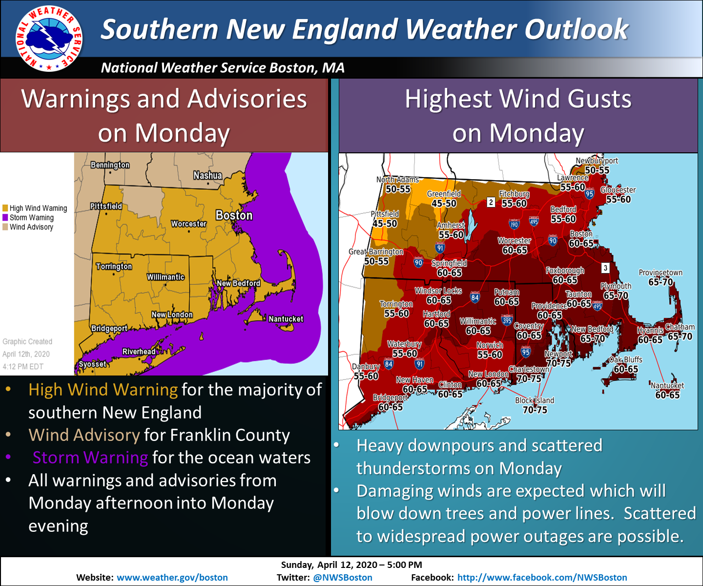
..A powerful storm system on Monday is on track bring the potential for widespread strong to damaging winds, heavy downpours and the potential for isolated to scattered strong to severe thunderstorms for much of Southern New England. This will bear watching given the ongoing COVID-19 crisis response in the region..
..A High Wind Warning is now in effect for sustained winds of 25-40 MPH with gusts of 65-70 MPH and isolated to scattered high wind gusts likely particularly in Southeast Massachusetts and Rhode Island. The timeframe for the warning is 12-7 PM Monday for Northern Connecticut, Hampden, Hampshire, Worcester and Northern Middlesex Counties of Massachusetts, 1 to 7 PM for Providence County Rhode Island, 1-10 PM for the rest of Rhode Island, 3-10 PM for Bristol, Plymouth and Norfolk Counties of Massachusetts, 3-7 PM for Essex, Central and Southeast Middlesex and Suffolk Counties of Massachusetts, and 4-10 PM for Cape Cod and the Islands. These winds could cause scattered to numerous trees and wires to come down and scattered to numerous power outages..
..A Wind Advisory is now in effect for Franklin County Massachusetts from 12-8 PM Monday for sustained winds 15-20 MPH with gusts to 55 MPH. These winds will cause isolated to scattered pockets of tree and wire damage and isolated to scattered power outages..
..The Storm Prediction Center (SPC) has placed areas from Southeast New York, the New York City area , extreme Western Connecticut and points south in a marginal to slight risk of severe weather for Monday. This risk area could move further north into portions Southern New England in future updates and will be monitored..
..Heavy downpours and potential thunderstorms are expected to drop 1-2″ of rain across much of the region with isolated amounts of greater than 2″ of rain possible. This could lead to urban and poor drainage flooding in the most flood prone areas. The Weather Prediction Center has continued much of New England in a marginal risk for excessive rainfall..
..Coastal Flooding is not anticipated across the south coast of Massachusetts and Rhode Island but elevated water levels at the time of high tide are possible in this area and will be monitored closely..
..SKYWARN Self-Activation with Amateur Radio Call-Up Nets are likely Monday for the strong to damaging winds, strong to severe thunderstorm and excessive rainfall potential. Pictures of storm damage can be sent as a reply to this email, via our Facebook/Twitter feed or via the email address pics@nsradio.org..
A powerful storm system is on track to affect the region on Monday and will bring the potential for strong to very damaging winds for much of the region and even another potential round of isolated to scattered strong to severe thunderstorms for portions of Southern New England. The headlines depict the latest thinking which continues to grow in confidence particularly on the damaging wind threat. The three main key factors for this storm event remain as follows:
1.) The extent of strong to damaging winds and the ability for the winds to reach the surface both ahead of the storm system, in convective showers and downpours and in any strong to severe thunderstorms. At this time, higher end wind gusts are expected and is what’s modeled by most of the reliable model guidance given the strength of the storm system, the expected warmer temperatures and the mixing of the stronger winds to the surface in heavier downpours and any thunderstorms.
2.) The extent of strong to severe thunderstorm coverage in the region. At this time, general thunderstorms are forecast and the gradient winds will be the predominant wind damage threat with severe thunderstorms expected to be further south and east of our coverage area but there is still a possibility of severe thunderstorms possibly getting into parts of the region and will be monitored in future updates.
3.) Rainfall will be heavy at times but also moving fairly rapidly across the region. Nonetheless, given how heavy the rain could fall in areas of Southern New England, rainfall amounts of 1-2″ with isolated to scattered rainfall amounts of 2″ or more are possible. This could result in urban and poor drainage flooding in parts of the region.
SKYWARN Self-Activation with Amateur Radio Call-Up Nets are likely Monday for the strong to damaging winds, strong to severe thunderstorm and excessive rainfall potential. Pictures of storm damage can be sent as a reply to this email, via our Facebook/Twitter feed or via the email address pics@nsradio.org. The SKYWARN Coordinator team will doing as much as we can to monitor area Amateur Radio repeaters and the *NEW-ENG3* Echolink conference node 9123/IRLP 9123 reflector system. We will attempt to monitor the SKYWARN DMR channel for New England as well depending on volunteer Amateur Radio resources. Another coordination message will be posted by 1100 AM Monday Morning. Below is the NWS Boston/Norton High Wind Warning/Wind Advisory Statement, Hazardous Weather Outlook, Enhanced Hazardous Weather Outlook, Excessive Rainfall Outlook and Facebook Infographic:
NWS Boston/Norton High Wind Warning/Wind Advisory Statement:
https://kamala.cod.edu/ma/latest.wwus71.KBOX.html
NWS Boston/Norton Hazardous Weather Outlook:
https://kamala.cod.edu/ma/latest.flus41.KBOX.html
NWS Boston/Norton Enhanced Hazardous Weather Outlook:
https://www.weather.gov/box/ehwo
WPC Day-2 Excessive Rainfall Outlook:
https://www.wpc.ncep.noaa.gov/qpf/ero.php?opt=curr&day=2
NWS Boston/Norton Facebook Infographic:
https://wx1box.org/wp-content/uploads/2020/04/93111680_2866722356755450_3275280663372103680_o.png
Respectfully Submitted,
Robert Macedo (KD1CY)
ARES SKYWARN Coordinator
Eastern Massachusetts ARES Section Emergency Coordinator
Home Phone #: (508) 994-1875 (After 6 PM)
Home/Data #: (508) 997-4503 (After 6 PM)
Work Phone #: 508-346-2929 (8 AM-5 PM)
Email Address: rmacedo@rcn.com
http://ares.ema.arrl.org
http://beta.wx1box.org
Like us on Facebook – http://www.facebook.com/wx1box
Follow us on Twitter – http://twitter.com/wx1box