
Storm Coordination Message #3 – late Sunday Night 12/17/23-Monday Evening 12/18/23 Coastal Storm Hazards
..A strong coastal storm will bring another round of strong to damaging winds and heavy rainfall to much of Southern New England with the potential for minor to low-end moderate coastal flooding to South Coastal Massachusetts and Rhode Island late Sunday Night through Monday Evening. This storm system is more intense and will intensify significantly on approach and over Southern New England which means the potential for strong to damaging winds could be more widespread than the event early last week..
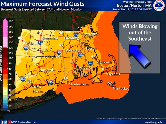
..A High Wind Warning is now in effect from 5 AM to 7 PM Monday for Rhode Island, Cape Cod and the Islands, Bristol, Plymouth, Norfolk, Southeast Middlesex, Suffolk and Eastern Essex Counties of Massachusetts for sustained winds of 30-45 MPH and gusts 60-65 MPH with isolated higher gusts possible and the highest gusts over coastal Southern New England. These winds will cause scattered pockets of tree and power line damage and scattered power outages..
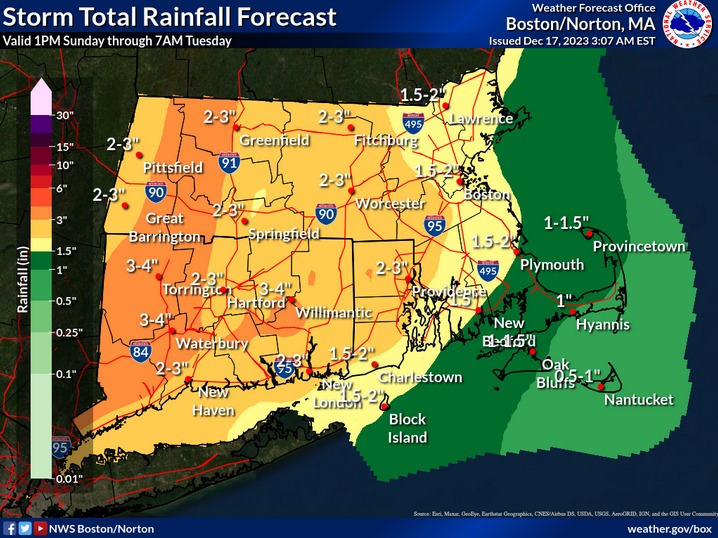
..A Flood Watch remains in effect from Sunday Evening to Monday Evening for Northern Connecticut, Northwest Providence County Rhode Island, Franklin, Hampshire, Hampden and Worcester Counties of Massachusetts and has been expanded to include North-Central Middlesex, Western Norfolk, Northern Bristol Counties of Massachusetts and Kent and Southeast Providence Counties of Rhode Island for a widespread 2-3″ of rain with higher amounts of 3-4″+ possible. These rains coupled with the rains from early last week bring the potential for flooding of urban, poor drainage areas, small rivers and streams..
..A Coastal Flood Watch remains in effect for the Monday Midday High Tide for Southeast Providence, Eastern Kent, Washington and Newport Counties of Rhode Island for minor to low-end moderate coastal flooding of shore roads in this area. Additional coastal flood headlines for South Coastal Massachusetts are possible in future updates. This will depend on the strongest winds coinciding before and during that high tide cycle..
..SKYWARN Self-Activation with Amateur Radio repeater monitoring will monitor for rain gauge, flooding, measured wind gusts 40 MPH or greater and wind damage reports for this storm system. The peak of the storm will be Monday Morning through mid-afternoon. Pictures and videos of storm damage and flooding and can be sent as a reply to this message, via our WX1BOX Facebook and Twitter feeds and via the email address pics@nsradio.org..
Another storm system will bring the potential for strong to damaging winds, heavy rainfall and the potential of minor to low-end moderate coastal flooding if the strong to damaging winds are before and during the Monday high tide cycle. The headlines depict the current thinking with High Wind Warning and Wind Advisories posted for the region, Flood Watches expanded into portions of Eastern Massachusetts and into the Providence, RI area and Coastal Flood Watches continue for the south coast of Rhode Island. Key factors include:
1.) This is a strong/deeper coastal storm system than the one early last week. With the storm last week, approximately 14,000 customers lost power in Southern New England with close to 9,000 in Massachusetts. The strong wind gusts forecast did materialize but were in pockets and isolated to pockets where heavier rain and convective showers brought the winds down to the surface. It was also noted that areas just inland of some coastal areas also had some of the strongest winds. Where this storm will be stronger and intensifying near or over Southern New England, it is likely that this will allow for winds of similar magnitude as last week but over a larger area which could create more scattered pockets of wind damage and power outages than the last storm event. This is reflected with High Wind Warnings and Wind Advisories across all of the coverage area.
2.) Heavy rainfall and renewed potential for flooding is possible across portions of Western and Central Massachusetts, Connecticut and now looks to extend into the Providence, Taunton area through Western Norfolk Counties into portions of Middlesex County Massachusetts with 2-3″ of rain with isolated higher amounts of 4″+ where Flood Watches are now posted. A widespread 1-2″ of rain with isolated higher amounts are expected in the remainder of Southern New England with more nuisance type flooding possible.
3.) A Coastal Flood Watch is now in effect for South Coastal Rhode Island for minor to low-end moderate coastal flooding is possible at the time of high tide if strong winds occur before and during the Monday midday high tide cycle. Additional coastal flood headlines for South Coastal Massachusetts are likely in future updates.
SKYWARN Self-Activation with Amateur Radio repeater monitoring will monitor for rain gauge, flooding, measured wind gusts 40 MPH or greater and wind damage reports for this storm system. The peak of the storm will be Monday Morning through mid-afternoon. Pictures and videos of storm damage and flooding and can be sent as a reply to this message, via our WX1BOX Facebook and Twitter feeds and via the email address pics@nsradio.org. The next coordination message will be posted by 11 PM Sunday Evening. Below is the NWS Boston/Norton Area Forecast Discussion, Flood Watch Statement with Rainfall Map, High Wind Watch Statement with Wind Gust Map, Coastal Flood Watch Statement and Enhanced Hazardous Weather Outlook:
NWS Boston/Norton Area Forecast Discussion:
https://forecast.weather.gov/product.php?site=NWS&issuedby=BOX&product=AFD&format=CI&version=1&glossary=1&highlight=off
NWS Flood Watch Statement & Rainfall Map:
https://forecast.weather.gov/product.php?site=NWS&issuedby=BOX&product=FFA&format=CI&version=1&glossary=1&highlight=off
https://wx1box.org/wp-content/uploads/2023/12/NWS_Norton_Rainfall_Map_Monday_12_18_23_Rev_2.jpg
NWS Boston/Norton High Wind Warning/Wind Advisory Statement & Wind Gust Map:
https://forecast.weather.gov/product.php?site=NWS&issuedby=BOX&product=NPW&format=CI&version=1&glossary=1&highlight=off
https://forecast.weather.gov/product.php?site=NWS&issuedby=BOX&product=CFW&format=CI&version=1&glossary=1&highlight=off
NWS Boston/Norton Enhanced Hazardous Weather Outlook:
https://www.weather.gov/erh/ghwo?wfo=box
Respectfully Submitted,
Robert Macedo (KD1CY)
ARES SKYWARN Coordinator
Eastern Massachusetts ARES Section Emergency Coordinator
Home Phone #: (508) 994-1875
Home/Data #: (508) 997-4503
Email Address: rmacedo@rcn.com
https://ares.ema.arrl.org
https://www.wx1box.org
Like us on Facebook – https://www.facebook.com/wx1box
Follow us on Twitter – https://twitter.com/wx1box
Subscribe on YouTube – https://www.youtube.com/@wx1box-nwsboston-amateur-radio