Severe Weather Coordination Message #1 – Tuesday Afternoon/Evening 5/31/22 Severe Weather Potential

Hello to all…

..Isolated Strong to Severe Thunderstorms are possible Tuesday Afternoon into early evening across Western Massachusetts and Northwest Connecticut to the west of a backdoor cold front where western areas will remain warm and muggy and to the east of the backdoor cold front conditions are cooler and more stable. The position of this front and the ability for thunderstorms to form and break a cap to tap into favorable instability and shear profiles will be the key factors in isolated strong to severe thunderstorm coverage in Western New England..
..The Storm Prediction Center (SPC) has placed portions of Western Massachusetts and Northwest Connecticut in a marginal risk for severe weather with the severe weather potential timeframe in the Tuesday mid to late afternoon into early evening..
..SKYWARN Self-Activation will monitor severe weather potential for this Tuesday Afternoon and Evening. This will only coordination message as we shift into operations mode. Below is the NWS Boston/Norton Area Forecast Discussion and SPC Day-1 Convective Outlook..

NWS Boston/Norton Area Forecast Discussion:
https://forecast.weather.gov/product.php?site=NWS&issuedby=BOX&product=AFD&format=CI&version=1&glossary=1&highlight=off

SPC Day-1 Convective Outlook:
https://www.spc.noaa.gov/products/outlook/day1otlk.html

Respectfully Submitted,

Robert Macedo (KD1CY)
ARES SKYWARN Coordinator
Eastern Massachusetts ARES Section Emergency Coordinator
Home Phone #: (508) 994-1875 (After 6 PM)
Home/Data #: (508) 997-4503 (After 6 PM)
Work Phone #: 508-346-2929 (8 AM-5 PM)
Email Address: rmacedo@rcn.com
http://ares.ema.arrl.org
http://www.wx1box.org
Like us on Facebook – http://www.facebook.com/wx1box
Follow us on Twitter – http://twitter.com/wx1box

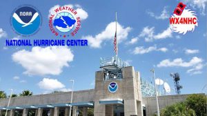
WX4NHC, the Amateur Radio Station at the National Hurricane Center, Annual Station Test 2022 Report

WD4R-Julio Ripoll, Assistant WX4NHC Coordinator Writes:

WX4NHC Annual Station Test 2022 Report:

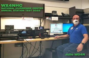
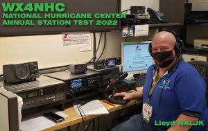
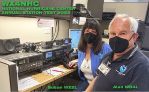
After 2 years of our dedicated volunteer Ham Radio Operators working remotely from our home stations due to Covid, we operate from inside NHC for our annual test event on May 28th. (All our Ops were fully Covid vaccinated.) This is our 42nd year of volunteer communication services for the National Hurricane Center. The Test event was successful as all our radios and antennas performed well. In 8 hours, we made 289 contacts nationwide and international using HF, VHF, UHF radios and digital communications modes. Thanks to all our volunteer Ops for their continued efforts and for all the stations worldwide that help during hurricanes.

WX4NHC Annual Communication Test
Saturday May 28th, 2022

9am-11am: WD4R Julio (NHC)
11am-1pm: N4JLK Lloyd (NHC)
1pm-3pm: WX2L Susie & WB4L Alan (NHC)
3pm-5pm: KG4USN Ken (Remote)

Happy Memorial Day and thank you to all who served and sacrificed for our freedom!

73, Julio – WX4NHC/WD4R


Severe Weather Coordination Message #2 – Saturday 5/28/22 Severe Weather Potential

Hello to all…

..Isolated to Scattered Strong to Severe Thunderstorms remain possible Saturday Afternoon into early evening any time between 12-6 PM across interior Southern New England along and north and west of the I-95 corridor. Strong to damaging winds, hail, frequent lightning, and heavy rainfall with urban and poor drainage flooding are the main threats. The Storm Prediction Center (SPC) has continued interior Southern New England in a marginal risk for severe weather along and north and west of the I-95 corridor..
..SKYWARN Self-Activation will monitor the severe weather potential for Saturday Afternoon and Evening..

A frontal system will cross Southern New England Saturday afternoon into the early evening with the potential for isolated to scattered strong to severe thunderstorms. The headlines depict the current thinking which is little changed from last night. Key factors that are also little changed from last night include:

1.) Morning showers and thunderstorms and their evolution into isolated strong to severe thunderstorms as the day progresses along with clearing behind this activity to allow for more isolated to scattered strong to severe thunderstorms to allow for heating and destabilization to increase instability levels.
2.) Cooling aloft in the atmosphere to also increase instability
3.) Overlap of instability with sufficient wind shear profiles to allow for isolated to scattered strong to severe thunderstorm development.

SKYWARN Self-Activation will monitor the severe weather potential for Saturday Afternoon and Evening. This will be the last coordination message as we shift into operations mode. Below is the NWS Boston/Norton Area Forecast Discussion and SPC Day-1 Convective Outlook:

NWS Boston/Norton Area Forecast Discussion:
https://forecast.weather.gov/product.php?site=NWS&issuedby=BOX&product=AFD&format=CI&version=1&glossary=1&highlight=off

SPC Day-1 Convective Outlook:
https://www.spc.noaa.gov/products/outlook/day1otlk.html

Respectfully Submitted,

Robert Macedo (KD1CY)
ARES SKYWARN Coordinator
Eastern Massachusetts ARES Section Emergency Coordinator
Home Phone #: (508) 994-1875 (After 6 PM)
Home/Data #: (508) 997-4503 (After 6 PM)
Work Phone #: 508-346-2929 (8 AM-5 PM)
Email Address: rmacedo@rcn.com
http://ares.ema.arrl.org
http://www.wx1box.org
Like us on Facebook – http://www.facebook.com/wx1box
Follow us on Twitter – http://twitter.com/wx1box
Severe Weather Coordination Message #1 – Saturday Afternoon and Early Evening 5/28/22 Severe Weather Potential

Hello to all…

..Isolated to Scattered Strong to Severe Thunderstorms are possible Saturday Afternoon into early evening any time between 12-6 PM across interior Southern New England along and north and west of the I-95 corridor. Strong to damaging winds, hail, frequent lightning, and heavy rainfall with urban and poor drainage flooding are the main threats. The Storm Prediction Center (SPC) has interior Southern New England in a marginal risk for severe weather along and north and west of the I-95 corridor..
..SKYWARN Self-Activation will monitor the severe weather potential for Saturday Afternoon and Evening..

A frontal system will cross Southern New England Saturday afternoon into the early evening with the potential for isolated to scattered strong to severe thunderstorms. The headlines depict the current thinking. Key factors include:

1.) Overnight showers and thunderstorms and their evolution to allow for clearing in the morning for heating and destabilization to increase instability levels.
2.) Cooling aloft in the atmosphere to also increase instability
3.) Overlap of instability with sufficient wind shear profiles to allow for isolated to scattered strong to severe thunderstorm development.

SKYWARN Self-Activation will monitor the severe weather potential for Saturday Afternoon and Evening. Another coordination message will be posted by 11 AM Saturday Morning. Below is the NWS Boston/Norton Area Forecast Discussion and SPC Day-2 Convective Outlook:

NWS Boston/Norton Area Forecast Discussion:
https://forecast.weather.gov/product.php?site=NWS&issuedby=BOX&product=AFD&format=CI&version=1&glossary=1&highlight=off

SPC Day-2 Convective Outlook:
https://www.spc.noaa.gov/products/outlook/archive/2022/day2otlk_20220527_1730.html

Respectfully Submitted,

Robert Macedo (KD1CY)
ARES SKYWARN Coordinator
Eastern Massachusetts ARES Section Emergency Coordinator
Home Phone #: (508) 994-1875 (After 6 PM)
Home/Data #: (508) 997-4503 (After 6 PM)
Work Phone #: 508-346-2929 (8 AM-5 PM)
Email Address: rmacedo@rcn.com
http://ares.ema.arrl.org
http://www.wx1box.org
Like us on Facebook – http://www.facebook.com/wx1box
Follow us on Twitter – http://twitter.com/wx1box
Heat & Severe Weather Coordination Message #3 – Sunday 5/22/22 Heat & Severe Weather Potential

Hello to all…

..Intense Heat & Humidity ongoing this weekend away from the east and south coastal areas so continue to use caution outdoors with any strenuous activities, drink plenty of uncaffeinated liquids and find locations to cool off if out in the heat and humidity for an extended period of the time. A Heat Advisory remains in effect through 8 PM Sunday Evening for the entire NWS Norton Coverage area except for the East Slopes of the Berkshires, South Coastal Rhode Island and East and South Coastal Massachusetts for heat indices to 100 degrees. .
..There remains the potential for isolated to scattered strong to severe thunderstorms on Sunday Afternoon and Evening in interior portions of Southern New England. The Storm Prediction Center (SPC) has continued most of Southern New England in a marginal risk of severe weather with areas of Western and Northwest Massachusetts and Northwest Connecticut in a slight risk for severe weather for Sunday Afternoon and Evening. The greatest risk for severe weather is in the slight risk area and interior portions of Southern New England away from coastal Southern New England between 2-10 PM Sunday..
..Strong to damaging winds, hail, frequent lightning and heavy downpours leading to urban and poor drainage flooding are the main threats with any strong to severe thunderstorms Sunday..
..SKYWARN Self-Activation will monitor the severe weather potential for Sunday Afternoon and Evening..

Intense heat and humidity will affect Southern New England this weekend with heat advisories posted for most of the NWS Norton coverage area as posted in the headlines of the message. There remains the risk for strong to severe thunderstorms Sunday Afternoon and Evening in the slight risk of severe weather area in Western and Northwest Massachusetts and Northwest Connecticut and interior portions of Southern New England. The headlines depict the current thinking. The main key factor in the severe weather potential for Sunday will be the forcing of the cold front timed close enough to peak heating of the day to take advantage of high instability and marginally sufficient wind shear that’s in place for isolated to scattered strong to severe thunderstorms to develop along with some potential for isolated strong to severe thunderstorms earlier in the afternoon with a prefrontal trough tapping into to potentially good instability and marginally favorable wind shear in the earlier portions of the afternoon.

SKYWARN Self-Activation will monitor the severe weather potential for Sunday Afternoon and Evening. This will be the last coordination message on Sunday’s severe weather potential as we shift to operations mode. Below is the NWS Boston/Norton Heat Advisory Statement and Graphics, Area Forecast Discussion and SPC Day-1 Convective Outlook:

NWS Boston/Norton Heat Advisory Statement:
https://kamala.cod.edu/ma/latest.wwus71.KBOX.html

NWS Boston/Norton Heat Advisory and Heat Indices Graphics:
https://wx1box.org/wp-content/uploads/2022/05/heat_advisory-1.png
https://wx1box.org/wp-content/uploads/2022/05/Max-Temp-May-22.png
https://wx1box.org/wp-content/uploads/2022/05/Heat-Index-Chart1.png

NWS Boston/Norton Area Forecast Discussion:
https://forecast.weather.gov/product.php?site=NWS&issuedby=BOX&product=AFD&format=CI&version=1&glossary=1&highlight=off

SPC Day-1 Convective Outlook:
https://www.spc.noaa.gov/products/outlook/day1otlk.html

Respectfully Submitted,

Robert Macedo (KD1CY)
ARES SKYWARN Coordinator
Eastern Massachusetts ARES Section Emergency Coordinator
Home Phone #: (508) 994-1875 (After 6 PM)
Home/Data #: (508) 997-4503 (After 6 PM)
Work Phone #: 508-346-2929 (8 AM-5 PM)
Email Address: rmacedo@rcn.com
http://ares.ema.arrl.org
http://www.wx1box.org
Like us on Facebook – http://www.facebook.com/wx1box
Follow us on Twitter – http://twitter.com/wx1box
Heat & Severe Weather Coordination Message #2 – Sunday Afternoon and Evening 5/22/22 Heat & Severe Weather Potential

Hello to all…

..Intense Heat & Humidity ongoing this weekend away from the east and south coastal areas so continue to use caution outdoors with any strenuous activities, drink plenty of liquids and find locations to cool off if out in the heat and humidity for an extended period of the time. A Heat Advisory is remains in effect through 8 PM Sunday Evening for the entire NWS Norton Coverage area except for the East Slopes of the Berkshires, South Coastal Rhode Island and East and South Coastal Massachusetts for heat indices to 99 degrees. .
..There remains the potential for isolated to scattered strong to severe thunderstorms on Sunday Afternoon and Evening in interior portions of Southern New England. The Storm Prediction Center (SPC) has placed most of Southern New England in a marginal risk of severe weather with areas of Western and Northwest Massachusetts and Northwest Connecticut in a slight risk for severe weather for Sunday Afternoon and Evening. The greatest risk for severe weather is in the slight risk area and interior portions of Southern New England away from coastal Southern New England between 2-10 PM Sunday..
..Strong to damaging winds, hail, frequent lightning and heavy downpours leading to urban and poor drainage flooding are the main threats with any strong to severe thunderstorms Sunday..
..SKYWARN Self-Activation will monitor the severe weather potential for Sunday Afternoon and Evening..

Intense heat and humidity will affect Southern New England this weekend with heat advisories posted for most of the NWS Norton coverage area as posted in the headlines of the message. There remains the risk for strong to severe thunderstorms Sunday Afternoon and Evening in the slight risk of severe weather area in Western and Northwest Massachusetts and Northwest Connecticut and interior portions of Southern New England. The headlines depict the current thinking. The main key factor in the severe weather potential for Sunday will be the forcing of the cold front timed close enough to peak heating of the day to take advantage of high instability and marginally sufficient wind shear that’s in place for isolated to scattered strong to severe thunderstorms to develop.

SKYWARN Self-Activation will monitor the severe weather potential for Sunday Afternoon and Evening. Another coordination message will be posted on Sunday’s severe weather potential by 11 AM Sunday Morning. Below is the NWS Boston/Norton Heat Advisory Statement and Graphics, Area Forecast Discussion and SPC Day-2 Convective Outlook:

NWS Boston/Norton Heat Advisory Statement:
https://kamala.cod.edu/ma/latest.wwus71.KBOX.html

NWS Boston/Norton Heat Advisory and Heat Indices Graphics:
https://wx1box.org/wp-content/uploads/2022/05/heat_advisory.png
https://wx1box.org/wp-content/uploads/2022/05/MaxT_SunMay22.png

NWS Boston/Norton Area Forecast Discussion:
https://forecast.weather.gov/product.php?site=NWS&issuedby=BOX&product=AFD&format=CI&version=1&glossary=1&highlight=off

SPC Day-2 Convective Outlook:
https://www.spc.noaa.gov/products/outlook/archive/2022/day2otlk_20220521_1730.html

Respectfully Submitted,

Robert Macedo (KD1CY)
ARES SKYWARN Coordinator
Eastern Massachusetts ARES Section Emergency Coordinator
Home Phone #: (508) 994-1875 (After 6 PM)
Home/Data #: (508) 997-4503 (After 6 PM)
Work Phone #: 508-346-2929 (8 AM-5 PM)
Email Address: rmacedo@rcn.com
http://ares.ema.arrl.org
http://www.wx1box.org
Like us on Facebook – http://www.facebook.com/wx1box
Follow us on Twitter – http://twitter.com/wx1box

Heat & Severe Weather Coordination Message #1 – Heat Potential – Weekend of 5/21-5/22/22 – Severe Weather Potential Friday Night 5/20-Sunday 5/22/22

Hello to all…

..Intense Heat & Humidity is expected this weekend so use caution outdoors with any strenuous activities, drink plenty of liquids and find locations to cool off if out in the heat and humidity for an extended period of the time. There will also be the threat for isolated to scattered strong to severe thunderstorms on Sunday Afternoon and Evening in interior portions of Southern New England with a much lower chance of an isolated strong or possibly severe thunderstorm across Connecticut, Rhode Island and Southeast Massachusetts late tonight after 11 PM Friday Evening through 5 AM Saturday Morning..
..A Heat Advisory is now in effect from 8 AM Saturday to 8 PM Sunday for the entire NWS Norton Coverage area except for the East Slopes of the Berkshire, South Coastal Rhode Island and East and South Coastal Massachusetts for heat indices to 99 degrees..
..The Storm Prediction Center (SPC) has placed portions of interior Southern New England in a marginal to slight risk of severe weather for Sunday Afternoon and Evening for isolated to scattered strong to severe thunderstorms with strong to damaging winds, hail, frequent lightning and heavy downpours leading to urban and poor drainage flooding..
..SKYWARN Self-Activation will monitor the severe weather potential for overnight Friday and especially Sunday Afternoon and Evening..

Intense heat and humidity will affect Southern New England this weekend with heat advisories posted for most of the NWS Norton coverage area as posted in the headlines of the message. There are a couple chances for strong to severe thunderstorms with the greatest risk Sunday Afternoon and evening with a lower grade much more conditional risk overnight Friday Night.

For the Friday overnight potential, a mesoscale convective vortex or MCV is moving across Long Island and south of Long Island but is spreading heavy showers and isolated thunderstorms into Southern Connecticut. This is associated with the warm front which will move through the region overnight to bring the intense heat and humidity to the region. This complex along with instability moving in via an elevated mixed layer could bring a low chance of an isolated strong to possibly severe thunderstorm over Connecticut, Rhode Island and Southeast Massachusetts late tonight into the overnight hours and this will be monitored via SKYWARN Self-Activation.

A better chance for isolated to scattered strong to severe thunderstorms exists on Sunday Afternoon and Evening as a cold front moves through the region with high instability and sufficient wind shear in place. The key factor in the coverage and intensity of the strong to severe thunderstorms on Sunday will be the timing of the cold front close enough to peak heating for the severe weather potential to be realized. This will be better known as we get closer to Sunday in future model runs. Portions of interior Southern New England are in a marginal to slight risk of severe weather per SPC.

SKYWARN Self-Activation will monitor the severe weather potential for overnight Friday and especially Sunday Afternoon and Evening. Another coordination message will be posted on Sunday’s severe weather potential by 11 PM Saturday Evening. Below is the NWS Boston/Norton Heat Advisory Statement and Graphics, Area Forecast Discussion and SPC Day-3 Convective Outlook:

NWS Boston/Norton Heat Advisory Statement:
https://kamala.cod.edu/ma/latest.wwus71.KBOX.html

NWS Boston/Norton Heat Advisory and Heat Indices Graphics:
https://wx1box.org/wp-content/uploads/2022/05/heat_advisory.png
https://wx1box.org/wp-content/uploads/2022/05/Heat_Indices_Saturday.png
https://wx1box.org/wp-content/uploads/2022/05/Heat_Indices_Sunday.png

NWS Boston/Norton Area Forecast Discussion:
https://forecast.weather.gov/product.php?site=NWS&issuedby=BOX&product=AFD&format=CI&version=1&glossary=1&highlight=off

SPC Day-3 Convective Outlook:
https://www.spc.noaa.gov/products/outlook/archive/2022/day3otlk_20220520_0730.html

Respectfully Submitted,

Robert Macedo (KD1CY)
ARES SKYWARN Coordinator
Eastern Massachusetts ARES Section Emergency Coordinator
Home Phone #: (508) 994-1875 (After 6 PM)
Home/Data #: (508) 997-4503 (After 6 PM)
Work Phone #: 508-346-2929 (8 AM-5 PM)
Email Address: rmacedo@rcn.com
http://ares.ema.arrl.org
http://www.wx1box.org
Like us on Facebook – http://www.facebook.com/wx1box
Follow us on Twitter – http://twitter.com/wx1box

Severe Weather Coordination Message #2 – Late Monday Afternoon/Evening 5/16/22 Severe Weather Potential

Hello to all…

..Isolated to Scattered Strong to Severe thunderstorms are possible to likely over Western Massachusetts through Northern Connecticut as the Storm Prediction Center (SPC) has a slight risk for severe weather in this area with a marginal risk for severe weather further east through Eastern Massachusetts. Strong to damaging winds, hail, frequent lightning and heavy rainfall with urban and poor drainage flooding possible in the strong to severe thunderstorms. Threat timeframe is 5 PM-11 PM late Monday Afternoon and Evening with the main focus time 5-9 PM as storms will weaken after 9 PM with loss of heating..
..SKYWARN Self-Activation will monitor the severe weather potential for Monday Afternoon and Evening..

A cold front will swing through Southern New England and bring with it the potential for isolated to scattered strong to severe thunderstorms for late Monday Afternoon into Monday Evening. The headlines depict the current thinking. Key factors include:

1.) The timing of the cold front as earlier timing near the time of peak heating would increase the threat for severe weather while later timing would reduce the severe weather potential as instability decreases after sunset. Models are split up on the timing with the current outlook looking a bit later into the region but not quite as late as yesterday’s model runs so the severe weather threat looks highest in our coverage area from Franklin, Hampshire, Hampden Counties of Massachusetts and Hartford and Tolland counties of Connecticut west with some risk a bit further east into Worcester and Western Middlesex Counties as storms weaken. The severe weather threat remains isolated to scattered in Western and Central Massachusetts and Northern Connecticut with a greater threat in Eastern New York but this will be monitored closely.
2.) Wind shear will be strong and this could compensate for later timing of the cold front if its not timed well after sunset and this aspect will bear watching if the timing of the front is around the 7-9 PM timeframe.
3.) Eastern areas will likely see reduced severe weather potential regardless of items 1 and 2 due to marine effects with southerly winds bringing in the cooler ocean influence but will still be monitored for any severe weather potential.

SKYWARN Self-Activation will monitor the severe weather potential for Monday Afternoon and Evening. This will be the last coordination message as we shift into operations mode. Below is the NWS Boston/Norton Area Forecast Discussion and SPC Day-1 Convective Outlook:

NWS Boston/Norton Area Forecast Discussion:
https://forecast.weather.gov/product.php?site=NWS&issuedby=BOX&product=AFD&format=CI&version=1&glossary=1&highlight=off

SPC Day-1 Convective Outlook:
https://www.spc.noaa.gov/products/outlook/day1otlk.html

Respectfully Submitted,

Robert Macedo (KD1CY)
ARES SKYWARN Coordinator
Eastern Massachusetts ARES Section Emergency Coordinator
Home Phone #: (508) 994-1875 (After 6 PM)
Home/Data #: (508) 997-4503 (After 6 PM)
Work Phone #: 508-346-2929 (8 AM-5 PM)
Email Address: rmacedo@rcn.com
http://ares.ema.arrl.org
http://www.wx1box.org
Like us on Facebook – http://www.facebook.com/wx1box
Follow us on Twitter – http://twitter.com/wx1box

Severe Weather Coordination Message #1 – Monday Late Afternoon/Evening 5/16/22 Severe Weather Potential

Hello to all…

..Isolated to Scattered Strong to Severe thunderstorms are possible over Western Massachusetts through Northern Connecticut as the Storm Prediction Center (SPC) has a slight risk for severe weather in this area with a marginal risk for severe weather further east through Eastern Massachusetts. Strong to damaging winds, hail, frequent lightning and heavy rainfall with urban and poor drainage flooding possible in the strong to severe thunderstorms. Threat timeframe is 5 PM-11 PM late Monday Afternoon and Evening..
..SKYWARN Self-Activation will monitor the severe weather potential for Monday Afternoon and Evening..

A cold front will swing through Southern New England and bring with it the potential for isolated to scattered strong to severe thunderstorms for late Monday Afternoon into Monday Evening. The headlines depict the current thinking. Key factors include:

1.) The timing of the cold front as earlier timing near the time of peak heating would increase the threat for severe weather while later timing would reduce the severe weather potential as instability decreases after sunset. Models are split up on the timing with the current outlook looking a bit later into the region keeping the severe weather threat isolated to scattered in Western Massachusetts and Northern Connecticut with a greater threat in Eastern New York but this will be monitored closely.
2.) Wind shear will be strong and this could compensate for later timing of the cold front if its not timed well after sunset and this aspect will bear watching if the timing of the front is around the 7-9 PM timeframe.
3.) Eastern areas will likely see reduced severe weather potential regardless of items 1 and 2 due to marine effects with southerly winds bringing in the cooler ocean influence but will still be monitored for any severe weather potential.

SKYWARN Self-Activation will monitor the severe weather potential for Monday Afternoon and Evening. Another coordination message will be posted by 1130 AM Monday Morning. Below is the NWS Boston/Norton Area Forecast Discussion and SPC Day-2 Convective Outlook:

NWS Boston/Norton Area Forecast Discussion:
https://forecast.weather.gov/product.php?site=NWS&issuedby=BOX&product=AFD&format=CI&version=1&glossary=1&highlight=off

SPC Day-2 Convective Outlook:
https://www.spc.noaa.gov/products/outlook/archive/2022/day2otlk_20220515_1730.html

Respectfully Submitted,

Robert Macedo (KD1CY)
ARES SKYWARN Coordinator
Eastern Massachusetts ARES Section Emergency Coordinator
Home Phone #: (508) 994-1875 (After 6 PM)
Home/Data #: (508) 997-4503 (After 6 PM)
Work Phone #: 508-346-2929 (8 AM-5 PM)
Email Address: rmacedo@rcn.com
http://ares.ema.arrl.org
http://www.wx1box.org
Like us on Facebook – http://www.facebook.com/wx1box
Follow us on Twitter – http://twitter.com/wx1box

Special Announcement: WX4NHC Annual Station Communications Test – Saturday May 28th 2022

Hello to all…

WX4NHC, the Amateur Radio Station at the National Hurricane Center will be holding its annual Communications Test, Saturday May 28th, 2022 from 9 AM-5 PM EDT over a variety of modes and bands. The Amateur Radio station at the National Hurricane Center will be operational for this event as mentioned in the purpose of this event section of the announcement. We hope Amateur Radio Operators can participate in this test via the variety of modes available and additional details on test operations are listed below:

Announcement from WX4NHC
Amateur Radio Station at the National Hurricane Center, Miami Florida
WX4NHC will be On-The-Air for the Annual Communications Test
Saturday, May 28th , 2022 from 9AM- 5 PM EDT ( 1300z- 2100z)

This is our 42nd year of public service at NHC.

The purpose of this event is to test WX4NHC Amateur Radio Equipment and Antennas at NHC as well as Operator’s home equipment, antennas and computers prior to this year’s Hurricane Season, which starts June 1st and runs through November 30th.

This event is good practice for Ham Radio Operators world-wide to practice Amateur Radio communications available during times of severe weather.

We will be making brief contacts on many frequencies and modes, exchanging signal reports and basic weather data exchange (Sunny, Rain, Temperature, etc.) with any station in any location.

WX4NHC will be On-The-Air on HF, VHF, UHF , 2 & 30 meter APRS and WinLink wx4nhc@winlink.org subject must contain //WL2K.

We will try to stay on the Hurricane Watch Net frequency 14.325 MHz most of the time. Also 7.268 MHz depending on propagation.

However, we will be operating different frequencies depending on QRM.

You may be able to find us on HF by using one of the DX Spotting Networks,
Such as the DX Summit Web Site: http://www.dxsummit.fi/Search.aspx

We will also be on VoIP Hurricane Net 4pm-5pm EDT (2000-2100z)
(IRLP node 9219 / EchoLink WX-TALK Conference node 7203). http://www.voipwx.net/

WX4NHC will also make a few contacts on local VHF and UHF repeaters as well as Florida Statewide SARNET system to test our station equipment.

QSL Cards are available via WD4R.
Please send your card with a S.A.S.E.

Please do NOT send QSLs directly to the Hurricane Center address, as it will get delayed.

Due to security measures and COVID-19 Coronavirus Pandemic:
NO VISITORS will be allowed entry to NHC.

For more information about WX4NHC, please visit our website
www.wx4nhc.org

Thank you for your participation in the WX4NHC Annual Station Test event.

73, Julio – WX4NHC/WD4R

-.-.-.-.-.-.-.-.-.-.-.-.-.-.-.-.-.-
Julio Ripoll Architect WD4R
WX4NHC Amateur Radio Asst. Coordinator
www.wx4nhc.org
Celebrating 42 years at the
National Hurricane Center
www.nhc.noaa.gov
-.-.-.-.-.-.-.-.-.-.-.-.-.-.-.-.-.-

1 2